
Let’s face it, technology is everywhere. You may have read a lot of articles about digital detox, but to be honest, we really can’t live without technology anymore. Let’s make use of them to make our lives easier, shall we?
In our own travels, we make use of a lot of technology – there’s Waze when navigating in a foreign country using car rentals, the websites where we book our tickets, Airbnb, etc. When planning, we make use of the following:
Our Online Travel Itinerary Planning Process
Step 1: Research about your destination
Step 2: Plot everything on Google Maps
Step 3: Route Destinations on Google Maps and Plot your detailed itinerary
Step 4: Use weather forecast and plan your outfit!
Travel Planning Step #1: Research about your destination
It’s important to know as much information as you can about your target destination. For us, we use a combination of online research + kindle books from Amazon. Depending on how many days you plan to stay on a place, you can do a macro search by typing “no. of days” + itinerary + destination on Google (e.g. 21 day itinerary France). If you are short of time, I suggest buying a Rick Steves book because he usually has these 3 triangle marker that indicates that a place is a must-see. I normally start with those and list all of them on a paper.
Travel Planning Step #2: Plot everything on Google Maps
STAGE 1 GOOGLE MAPS PLAN – YOUR TRAVEL ITINERARY IN MACRO LEVEL
Go to http://www.google.com/mymaps and start creating your travel itinerary map. Plot your port of entry and exit, then use a different color for it. I am currently planning for our Italy-Swiss itinerary and it looks something like this:
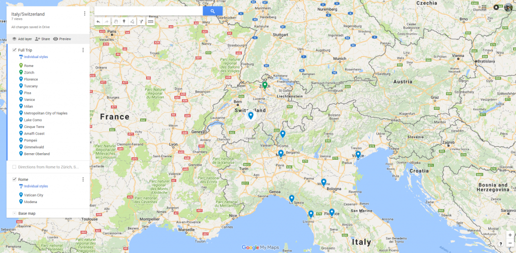
In google maps, you can zoom into the street level. This is a zoomed out version where I plotted the cities that I want to visit. At this stage, the cities are not yet final. The no. of cities you will visit depends on how long your trip would be and how fast or long you want to stay in a single city. For us, we take the time to appreciate the beauty of each city and normally stay 2-3 days per city, or longer if its a bigger city like Paris.
Travel Planning Step #2: Route destinations on Google Maps and Plot your detailed itinerary
STAGE 2 GOOGLE MAPS PLAN – CHECK DISTANCES FROM EACH CITY, HOW MANY HOURS IN TRAVEL TIME DO YOU NEED TO GET FROM ONE CITY TO ANOTHER?
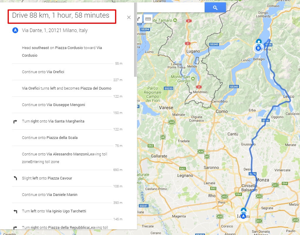
In this step, it is important to know how long it would take you from one city to another. This will help you gauge if you can visit all the cities you plotted with the amount of time you dedicated for that trip. Below is a sample macro-route I did when we planned our trip to France.
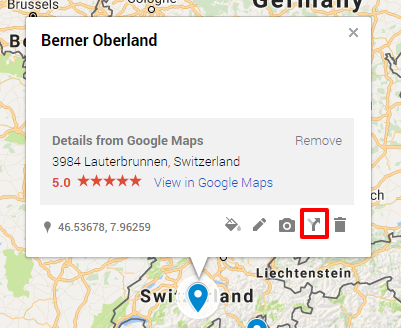
In Google Maps, you can create driving, walking or biking directions. You can also open a separate Google map window to check public transportation options like Trains and Buses. To do this, all you need to do is click on a map marker and click the directions icon as highlighted below:
This will route the 2 cities and give you an estimate on how long the travel will be. I normally compare this with public transpo and take the car rental if its faster. If taking the train is faster, we’ll lean towards taking the train.
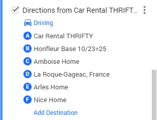
You can add more cities to the route as you wish. Here’s how we did it for our French trip:
Clicking on the Step-by-Step directions will give you an estimate on how many hours it will take from one marker to the next. Now that you already have an overview of your whole travel, its time to pin down the details.
STAGE 3 GOOGLE MAPS PLAN – PLOT PLACES TO VISIT PER CITY
At this stage, your research is on a city level. For example, if you are visiting Rome, research on must-see museums, must-try restaurants, secret places that locals love visiting and best photo locations. Plot each of the locations on your list and you can already group the places you will visit by day based on their proximity to each other. You can group places by layers on Google Maps. Problem is, Google maps allows a limited no. of layers so in my example below, I created a new map for Paris alone:
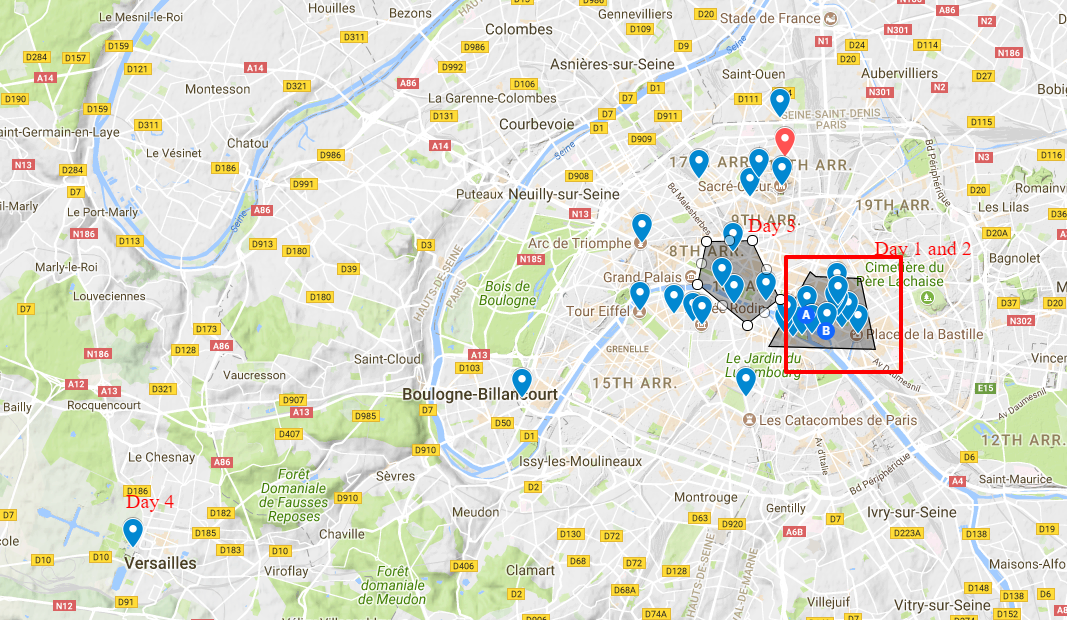
At this stage of your planning, you can already list down places to visit day by day. Things to consider are opening times of the attraction, the no. of hours you plan to stay at each (e.g. if its Louvre museum, you have to spend at least 6 hours in it), and proximity between each attraction.
This is also the stage where you decide where to stay. Ideally, you should book a place at the center of most of the places you want to visit so you have time to go home and rest after lunch or go home and leave things you bought to reduce your load. For accommodations, we normally book through Airbnb. Basically, Airbnb lets you rent rooms, entire houses or apartments on a daily basis (like a hotel) and you usually have access to amenities like washing machine and fully equipped kitchens. Get $20 savings on your first Airbnb booking here.
STAGE 4 GOOGLE MAPS PLAN – TIPS IN OPTIMIZING YOUR TRAVEL ITINERARY
Your last stage would be optimizing your travel itinerary. I advise doing the optimization a week before your trip. At this stage of your planning, you should already consider weather conditions. Review your travel itinerary and check the weather forecast per day. Ideally, you should visit indoor attractions like museums if there is rain in the forecast. Adjust your itinerary accordingly.
Last step is to download Google Maps on your phone, sign in and download your custom maps. You can also download the whole country or specific places in the city that you will go to so you don’t need to have internet connection to get directions 😉
Enjoy Travel!
For your travel, camping needs and essentials, shop at Philippine Camping Gears Online Shop.


1 Comment
I agree with all your tips. I was like that before but i ended up following 50 percent of my plan haha